Walkers Hill, Milk Hill and canal loop – 16 km circular with paragliders and White Horse views
I meant to write this blog post weeks ago but somehow time flew. Better late than never.
This was our “Rambling On Together” walk on 27th April, in Wiltshire.
This was a walk I did with Gary and Johnny on a warm, sunny day that offered everything I could hope for – stunning views, plenty of wildlife, and great company.
It was also the day after I first noticed some pain in my right knee. I wasn’t sure how I’d manage the walk, but with the help of hiking poles, it didn’t hurt at all on the day – a relief and a small win.
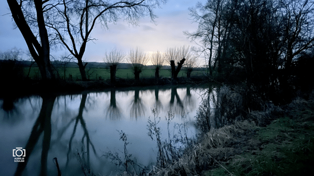
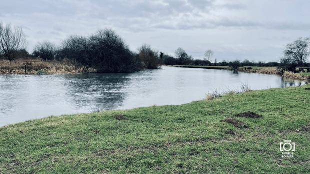
We set off from the Pewsey Downs car park and climbed onto the ridge before descending towards the canal. The walk along the towpath was peaceful and scenic. We made a welcome coffee stop at Honeystreet Café, which was just the thing for a short break in the sunshine.
We were treated to lots of wildlife throughout the walk. A couple of fields were full of large rabbits, and just a short while later, two deer crossed the path right in front of us. There were birds everywhere, and we passed plenty of cows and sheep, including some newborn lambs.
The climb back up through Alton Barnes and Alton Priors was steady and rewarding. We passed Walkers Hill (260 m) and the striking chalk figure of the Alton Barnes White Horse, before continuing up to Milk Hill (295 m) – the highest point in Wiltshire.
The views across the Pewsey Downs were absolutely breathtaking. We were lucky enough to see dozens of paragliders launching from the hills, catching the thermals and drifting above us. To top it all off, we saw biplanes flying in formation overhead just as we were making our way back to the car park.
As always with Gary and Johnny, there was plenty of laughter and easy conversation. It really was a special day – one of those walks that stays with you.
12 April 2025 Distance: 15.88 km Elevation Gain: 420 m
Route: Dinas Rock → Pull Berw → Sgwd yr Eira → Sgwd y Pannwr → Sgwd Isaf Clun Gwyn → Sgwd Clun Gwyn → Sgwd Ddwli Uchaf → Sgwd y Bedol → Sgwd Gwladus
A week ago today, a group of us (Kerry, Gary, Johnny and I) embarked on an early morning adventure, setting off at 06:30 and arriving at Dinas Rock before 09:00, with a brief coffee and convenience stop in Merthyr Tydfil.
The plan was to walk an extended version of the Four Waterfalls Walk, and it delivered as we saw over 10 waterfalls.
We started the walk with a steep couple of climbs!
Our journey began with Pull Berw, a serene introduction to the cascading wonders ahead.
The path to Sgwd yr Eira was both challenging and rewarding.
We witnessed some smoke and flames, along a ridge in the distance – wildfires. It’s sobering reminder of nature’s fragility.
Walking behind the curtain of water at Sgwd yr Eira was a highlight, offering a unique perspective of nature’s power. Then we faced the 170 steps back up the path that tested our endurance.
The trail continued to Sgwd Isaf Clun Gwyn, where a steep scramble added an element of adventure.
Lunch at Sgwd Ddwli Uchaf provided a moment of respite, accompanied by the soothing sounds of flowing water…until a lot of families arrived and we felt it was time to move on.
We then left the Four waterfalls area and headed onto the Elidir trail.
A delightful detour to Clyngwyn Farm Bunkhouse and Café offered a sweet treat. I had an ice cream. The misspelt “Barra brith” on the menu brought a chuckle(I need to learn not to correct people on spelling in their own language!), but the warm hospitality and delicious offerings made it a memorable stop.
The next stretch, past some farms and along a stream up to Pont Melin Fach didn’t feature waterfalls but was really pleasant and picturesque along the steam.
There started the new streak of Waterfalls – we saw the sixth waterfall of the day: Sgwd Ddwli Uchaf. And then so many that we stopped counting…
A surprise awaited us at Sgwd y Bedol—a lone swimmer embracing nature in its purest form! We didn’t need these sights! I’ll spare you the photo of the man to keep his privacy… But to be fair I don’t think he had any concerns about keeping himself private at all!
The final stretch led us to Sgwd Gwladus, where we once again walked behind the waterfall, just after an unexpected slip reminded me of the trail’s unpredictability. I didn’t get hurt. Just my ego bruised!
The Bannau Brycheiniog never ceases to amaze. Each waterfall, each path, and each unexpected moment contributed to a day filled with laughter, awe, and a deep appreciation for the natural world.
I’d been there twice before but each time it feels different and looks different, depending on the seasons and the company.
Sharing this experience with Kerry, Gary, and Johnny made it all the more special.
I woke up with the dawn chorus, feeling quite cold, and when looking outside, fog was covering all those beautiful views from last night. I warmed up with my breakfast (porridge and hot chocolate) and slowly started getting ready and packed for the day ahead. It was my last night out in the wild, and I had to pack this tent still damp from the mist. One thing that disgusted me was finding a slug on top of my sleeping bag! Yuck. I guess it got in the tent while I made and ate breakfast. It’s been a great experience but I don’t think I’m made for the fully outdoors life! I’m glad I did this for the last few days and got an experience unlike any others. But I’ll be glad not to have to carry my house with me everywhere after that 🐌.
When I woke up, I’d say the visibility was about 100m. By the time I set off, it had improved. Looking at my map, I estimated about 300m visibility. It improved as I walked along. I tried to keep a good pace to keep myself warm. I had all the layers and gloves, but it was a little windy and still cold.
I wore compression socks last night, and it may be the reason, but my right calf didn’t hurt as in previous days; I was especially conscious of it in the steep descent to Cwm Penmachno. It was pain-free.
The Eagles in Penmachno was closed and seemed to only open for evening meals, so I purchased some food and a big bottle of water at the Londis. I topped up my now empty Camelback and found a bin by the bus stop to throw the bottle away.
I found it hard to find directions out of Penmachno. Maybe tiredness or maybe I missed the signage? Then I climbed above Penmachno to the forest edge and carried on along the forest track for quite a while. I felt stronger, and my pace improved.
I saw some waterfalls, and then, as I planned to stop in the car park by the crossroads before the Conwy Falls for lunch, I realised there was a lovely café. It felt like luxury. The café owners/workers were so lovely. The all-day veggie breakfast was delicious, and there was a charging point where I topped up my power pack. I had two americanos, and the sun came out while I waited. The toilets were very clean and boasted a shower cubicle, which is worth knowing for wild campers, I guess? Not that I recommend wild camping here as it’s a busy car park!
At this point, I made the decision to end my Llwybr Llechi Eryri walk at Betws-y-Coed today. It’s been wonderful, but being tired, I don’t think I should push it further. I decided I would return by public transport to my booked accommodation from there. With that in mind, I decided to take my time and enjoy the Conwy Falls. It was £2, so be prepared to pay if you ever go there. I was just surprised, but I do understand contributions help keep the place safe and sustainable. The sun had come out to play, which made it a very lovely stroll. The falls were so impressive and powerful!
I was a little tired after the stroll around the woods. I took a break by the café and then set off for my last stretch from Conwy Falls to Betws-y-Coed. What a wonderful calming walk. It was sunny, but the tree-lined paths made it so pleasant. I arrived in Betws-y-Coed just before 16:30 and sat on a bench in the park, contemplating what I achieved in the last few days, before heading to the train/bus station.
I perhaps will come back one day and walk from Betws-y-Coed to Bethesda.
My advice
– Plan for all weathers! Overall I was lucky with the weather but it gets cold and windy in places. – Prepare to tackle hills. They are everywhere. But no rush, you can enjoy it and look around by slowing down. Also, the more you walk hills, the easier it gets. – Travel light: I had my struggles but anyone who’s more reasonable than me would not do it camping , by staying in accommodation and getting support/lifts + not carrying a heavy pack. Having a lighter bag would massively have improved my pace. – You need to like sheep a lot 🐑 😆 they will be everywhere! – Don’t be scared to walk through mud and waterlogged ground. Get proper waterproof boots (mine are expensive but didn’t let me down a single time). – Check your route before you go. Bring a map / make sure you have basic navigation skills in case you are in low visibility or in wilder areas with fewer signposts. – Have sufficient water and food. – Finally, enjoy! You don’t have to do the whole route. Do take detours to see sights you like. My favourite part hands up was Beddgelert to Nantmor. It’s short but challenging. I also loved the Bwlchgwernog area, just before Croesor.
For those of you who live in the area, go enjoy the beauty you have in your doorstep 💚
I hope you’ve enjoyed reading these walk reports. I hope it inspires some of you to spend time outdoors, be it for your own adventures, on this trail or elsewhere, or a day out in your local area. Feel free to ask me questions if I can help. I might not know the answer but I will try to help/ find out.
Being with nature is wonderful for the soul. Try it more often.
So what’s next?
I will be walking a marathon between Winchester and Salisbury on 2nd June in aid of Julia’s House Children’s hospice. If you can and would like to contribute, here is the fundraising page.
After that, I am tackling the Edale Skyline challenge with my friend Andrea mid-June (20 miles in 8h – not sure I can do that!). I’ll try to blog about this. Then my walking adventures will be on a break until late October while I train for my first-ever half marathon. (Scary)
Diolch Eryri am yr antur! Wela’i di wedyn!
And with this, I wish you all happy rambling.
You can’t add days to your life, but you can add life to your days.
As I started day 3, I expected a slow day, aiming for 12 to 15 miles. I woke around 2:30 am to a beautiful night sky, though my camera couldn’t capture it. After getting up properly at 6 am, I delayed getting out of my sleeping bag due to the cold and fatigue.
After breakfast and chatting with other campers, Martin, a keen hiker and mountain leader, offered me coffee and introduced me to his wife Fran who walked across Iceland. We discussed hiking, with Martin diagnosing me as “insane” due to the weight if my bag! That’s about right.
I set off around 9 am, enjoying the sunny climb and later with majestic views of Yr Wyddfa and glimpses of the sea.
Descending to Rhyd Ddu, I stopped at a pub for a chocolate bar and apple juice before heading slowly to Beddgelert.
Despite enjoying the woods, I felt mentally fatigued. Concerns about finding accommodation and essentials like water and power troubled me. At Beddgelert, I couldn’t find anywhere to top up my power packs but charged up my devices on the charge I had left. Refueling at a café (bara brith and coffee ) improved my mood and I started to feel brighter as I walked along the riverbank, feeling refreshed. Even my bag didn’t feel that heavy.
The day’s path was drier overall. I had occasional cloudy weather but mostly sunny.
This is when I had what is perhaps the best mile I walked in my life.
Negotiating boulders and paths over the side of the river was exhilarating. Despite the challenges, I felt happier and more confident.
It goes to show about impermanence of situations. I’m not saying you should always push through but having a go at the next step before giving up is so important because you don’t know what’s around the corner. In my case from being tired and wanted to call it a day to exhilarating happy moments on the trail.
Hiking is always here to remind me of these life lessons.
Passing through Nantmor and Bwlchgwernog, I struggled to find a suitable camping spot due to wet ground.
Also, after the fun buzzing part, I had a “moment” of awe when in a proper wild unspoiled area with majestic views. I’m very lucky to have experienced this.
Eventually, I pitched my tent on a windy hillside above Croesor.
Limited phone connectivity made communication difficult, but I managed to send some messages before struggling to keep warm and falling asleep around 11 pm.
You won’t believe what happened in the night… Wait until the next blog, later on, you will have a good laugh at me!
Yesterday marked the start of my hike along the Snowdonia Slate Trail, a day of surprises, scenic wonders, and a mix of challenges and small wins.
Setting off on the train to Newport, I found myself chatting with the station staff, setting a cheerful tone for the day ahead. I had to find a fix (a headband) for my backpack’s loose buckle. I switch trains at Newport for the Transport for Wales train, (it had USB charging points!) and announcements in Welsh, adding an immersive touch to the journey.
Interestingly the toilet felt like a TARDIS and kept talking 😆 “door closed”…
Chatting with other passengers was lovely and the lady selling food and drinks explained the voice for announcements is called “Digital Doris” amongstbthe staff.
Arriving in Bangor, I stepped onto the trail, greeted by a picturesque bike path in the woods and by penrhyn castle. Yet, amidst the beauty, I couldn’t help but notice the reality of homelessness under the bridge (someone clearly lives there)—a stark reminder of the world’s complexities.
I kept walking, and the scenery got better – fields full of sheep and adorable baby lambs, and I stumbled upon a lovely spot with bluebells nestled between a couple of trees.
Then, along the fence next to the A55, it got a bit muddy in places, but the wooden path kept it wild enough. I couldn’t help but notice the cars zooming by through the bushes and trees – even played “yellow car”, just for fun.
After that, I struggled over and over again through kissing gates as my pack was too big for them. Taking my bag off, lifting it over the gate, going through, putting my bag back on, walking the length of the field, and starting again…). It slowed me down a lot and was tiring.
Despite the hurdles (pun intended), the journey was punctuated by moments of wonder, from the smell of wild garlic to the breathtaking views atop Charub quarry. Pushing onward towards Bethesda, I struggled with fatigue and the weight of my pack. I was on my own all day. No other hikers on the trail. Just a few dog walkers in towns.
Deciding against indulging in a warm meal and pint in Bethesda, I carried on past Bethesda. The quaint station caught my eye with its charming architecture, providing a brief respite before pushing onwards.
Leaving the town behind, I hoped for smoother terrain to pitch my tent. A massive hill loomed before me, challenging my resolve, but the breathtaking views and wildlife sightings offered ample reward.
Saw another yellow car!
Fortunately, the weather held, sparing me from the rain as I navigated through marshy, boggy ground and crossed streams with caution.
I pressed on, guided by a mix of determination and optimism. As dusk approached, I faced the daunting task of finding a suitable spot to pitch my tent. My first option was under power lines, so I moved on.
With limited options and the threat of rain looming, I made a quick decision, settling for a rocky patch near a house.With the worst of the pitching behind me, I treated myself to a comforting meal of pasta and a hot chocolate, a well-deserved reward after a challenging day on the trail.
Richard later shared, it was Judith’s birthday yesterday – I think she’d have like my little adventure.
Stay tuned for the next chapter of my journey in Snowdonia.
I started the walk around 08:00 from the Bridge in Cricklade, where I last stopped.
This last leg of the Thames Path has been much delayed so my rushed decision to get on the path today was definitely a very good one. A what a beautiful day for it!
I decided to return to using the DSLR camera for this last section, rather than using my phone for camera.
Shortly after I started walking, I managed to get lost following the path in Cricklade but soon re-joined it.
I met many people on the way and had some really lovely chats. The first couple I met was walking their dog, between Cricklade and Latton. From early on it was a warm day and I took my zipped long sleeve top off and was in my t-shirt for the rest of the day.
As I left Cricklade, you could hear the murmur of the A419 cars, the backdrop of planes in the sky but thankfully, also, the birdsongs closer to the ear which made the walk so pleasant.
By the lakes, I saw some people doing water-skiing and all along the walk, I met dog walkers. Just past Ashton Keynes, I saw Colin, who I hasn’t seen in ages. That was lovely.
Animals
robinstoatdragon flymums and calves
Flowers
Overall, my progress was slow due to taking pictures and chatting with people but I made the most of the beautiful day, and saw much wildlife, both flora and fauna, especially around the lakes, as I crossed the Cotswold Water Park. So many buttercups fields!
It felt quite sad to see so many trees cut down on the Thames side – especially by the fields that are trempled by cows already – there is a slight feeling of destruction and emptiness, in contrast with the lush fields, flowers and diversity in other neighbouring fields.
The paths got busier around the water part and Neigh Bridge Country Park.
On the Neigh Bridge path… you couldn’t make it up…
It’s been such a contrast to my earlier cold, lonely winter walks!
Cows
If you read my earlier posts, you may remember a near-miss incident with cows in a field… so I had a little stress when I saw these cows waiting at the end of a field… so I took to the left side to follow the field away from them.
Then a family arrived, from the opposite direction, and opened the gates. ALL the cows started to run and charge towards me! I was petrified. But I stayed as calm as possible. The family looked at me but none of them asked how I was. They just stared! I can’t describe how brainless one would be to do what they did. The other issue was that the farmer who had their cows in one field will have to find their cows. I was ok but I wasn’t happy.
Getting to the Source
I carried on until Ewen; there the Thames stared to get drier. I had my sandwich on a seat with a ‘Millenium seat’ plate on.
It was quite a sight to see the Thames’ bed empty after Ewen. Quite sad in fact. But I guess it’s the time of the year where this area is dry?
Here’s a shot from ‘within’ the Thames river bed, upstream and downstream.
Then it was a few more miles until I finally reached the Source. It is marked by a stone and a signpost. I chatted with a few more people there.
Then I made my way, across the trainline, to the local pub: the Thames Head Inn, to celebrate the end of the walk.
I am just having a glass of Champagne this evening, while writing this post to celebrate, too.
22km in about 6hours.
It took me a little longer than hoped due to detours, but, I DID IT! I completed the walk: the whole of the Thames Path from Barrier to Source.
STATS: I walked a total of 204 miles (326 km) and spent £830 in travel and accommodation costs in total over the 14 sections. I have a spreadsheet with all the details if anyone is interested.
Planning a mad 3-day walk in a fortnight, again… watch this space 🙂
I started back at St John’s Lock, by the Trout Inn, in Lechlade, with the sun shining this time, rather than in the dark. I was just one bridge away from Halfpenny bridge in Lechlade which should have been my finish yesterday. Today’s destination was Cricklade.. The gusts of wind were very strong but I wanted to make as much progress as possible before the stormy weather forecast for after 13:00 in the afternoon.
I’ve been looking forward to this part of the walk: practically on ‘home turf’ now.
Before 10am I walked up to the Roundhouse footbridge. It was sunny, but quite windy which made it much harder to progress especially as it was a headwind. I only did two kilometres in 45 minutes, but it was much better than yesterday, and it wasn’t raining.
Inglesham
The wind kept getting worse. At this point I checked the weather forecast app on my phone. I’d checked in the morning and saw it’s be cloudy and no rain until 15:00 but what I had failed to check was wind! the wind was blowing up to 45mph: no wonder I could barely stand, never mind walk, in places! It had now got very cloudy with an occasional drizzle.
I stopped to have my sandwich and got the raincover on my backpack before Hannington Wick, There the Thames path was diverted away from the Thames which wasn’t much fun, especially when the ground was so muddy. I saw a couple walking in the other direction. They came from Cricklade and they said they had seen no one else and be on the path so far today. At that point, I knew the rest of the walk would be very lonely.
Castle Eaton was nice but, just my luck again, the Red Lion pub was closed so no lunch and no break away from the wind, for me!
The Thames path got back to the bank of the Thames again for a bit. The wind was really really strong and I had nowhere to stop but I was really hungry and thirsty, and I started to get headache. After a while I stopped in a field. I just sat there with the gale force wind in my face, eating crisps and drinking water. After that, it took me a little while to start again, because I was getting really tired.
I found the Thames path completely flooded at this point, so I had to try and work my way around rather than turning back and giving up. I did go through quite a lot of high water. Thankfully, my shoes are still fairly waterproof and then re-joined the banks of the Thames and carried on.
From then on, I went through many other flooded areas of the path. At one point I went over the barbed-wire next to a gate and later literally climbed over a gate and jumped the best I could to not have to completely submerge my shoes.
I finished a challenging 11.78 miles (which is just over 56 miles or just over two marathons in four days). But I’ve just had a lovely cuppa at my friend Claire’s, in Cricklade which made it all worthwhile.
The next and last section of the path (12.5 miles) is planned for the end of the month, but the last part of today’s walk was so challenging with mud and the Thames bursting out in places, that I now doubt I will be able to do it this month.
Beautiful pink and red skies greeted me as I left Swindon on the bus this morning. Transport was a little stressful as I was quite close in connecting buses in Swindon but managed to get onboard. Then the bus towards Oxford was over 20 minutes late and I was close to miss that last connection but made it so that all turned out to be a good start.
Today was the first day in all 12 days so far on the walk when I had no idea where and what sort of time I might finish. The original plan was to walk to Lechlade but as I was so tired yesterday, I gave myself an option to end at Radcot and either walk 40min or take a taxi to the closest bus stop.
Spoiler alert: I made it to Lechlade!
It felt colder today and the wind and rain were already pretty awful when I left Newbridge , so I decided I needed to keep my head down and enjoy the views as much as I could, when I could.
I did take a smaller lighter backpack today , and I already had my rainproof trousers on from the start.
Since I left Newbridge, it was windy and rainy. Then I went through some woods that were practically impassable, having to walk through huge amounts of mud; I made myself some poles out of wood and basically sort of ice skated through the mud. It was pretty horrendous. It took me 45 minutes to do the first mile of the walk! Then as I left the woods, I was exposed again to the elements. I just put my head on and took a step at a time. What was nice was to see a lot of birds.
In the whole 30km today I’ve only see one person on the Path, all day. There were people at places where I stopped but no walkers at all. It is a very lonely and removed part of the walk, not helped in my case by the bad weather.
When I thought things were bad… I accidently then got my ring finger whacked between the wooden post and a metal gate! What an idiot! Suddenly it took my mind off the weather and any other struggles!
I managed to go wrong along the water at a footbridge before Chimney Meadow, as I failed to cross the footbridge. You can probably see that on the Strave map as a bleep 🙂 The riverside was treacherous so I had to be super careful. The waters were high as you can see in the photos so I went very very slow again.
The rain hadn’t stopped in hours. I found a bird observatory and stayed there for a bit of respite from the rain and wind, for about 15 minutes.
I found a hide and stopped for a few minutes
I eventually reached the Trout at Tadpole Bridge. I was hoping to dry a little bit get a restful 30 minutes, but it was closed! I stopped under a platform/shelter in the pub garden there for a few minute. I had a snack but I was getting cold. Everything was really really wet; my backpack was wet and even my waterproof gloves were wet. I wished for a little bit of a break in weather for five minutes…and when I set off again at about 14:00, the rain stopped!
The Trout at Tadpole Bridge was shut – no lunch break / no chance to dry for me.Plane from Brize NortonLock
Past Rushey Lock and Weir, I saw cows in the field and I walk past them fairly close but quite peacefully. I was brought up on a farm and never have had issues with cows. Then, as I went to exit the field, I took a bit of a wrong turn while struggling my way through the muddy field and carried on too far past the gate. At that point, I stopped to check my map and I heard a noise…I lifted my head an I saw them, all of them, running towards me. I hurried through the mud towards the gate to the corner of the field, closed the gate securely and then took a video (below) of them coming towards me. They obviously wanted food, but it was a little bit tense!
Before / After
Herd of cows coming running towards meSnow drops at the lockAnother plane from Brize Norton Eek – at Radcot Radcot
I arrived in Radcot around 16:00 and was offered a cuppa tea by one of the locals in the pub who were there and chatting with me about the walk. I dried my coat a little bit in front of the fire, put my gloves and hat on the radiator; I did change my socks, so I got fresh socks for a fresh start. My snood got dry so that was nice. I decided to carry on.
The sun set around 17:20. I walked in the dusk after Kelmscott Manor. There was a memorable moment when I heard a lot of crows: hundreds, I’d say, in the trees near Kelmscott Manor. It was very impressive. As I came closer, just at once, as if I’d dreamt it, the cacophony stopped abruptly. Not a single kraa to be heard!
The wind had died down, it was getting very dark and the river is very quiet there. I kept walking.
The Thames at dusk by Kelmscott
I arrived near Lechlade at St John’s lock in the dark, after 9h30 of walking.
Night pictures. Kelmscott to St John’s Lock.
That always a bonkers day of walking by my standards: somewhere between a nightmare, an adventure and a pilgrimage! I managed to make it to Lechlade after 1h30 in the dark. I was very glad I decided to press on after Radcot!
It’s been a difficult start of the day as I realised my top backpack pocket was open on the bus. My key was hanging out (luckily it’s strapped in with a hook) and my wallet was missing! I’d not slept well and with accumulated fatigue for days, it was starting to have an impact. I was very annoyed and getting upset. I stopped at the next possible stop and ran back to my bus stop. The wallet wasn’t there. And walked back home where I found it. What a panic. At that point I know I’d missed my train and I wouldn’t start on time (by 07:15) so I had to re-plan.
I headed for the next possible bus and train. And rescheduled my day, then making it very difficult to plan a lunch break. It also meant later finish and likely missing dinner time (it’s Valentine’s Day!).
Leaving Oxford, I could see allotments the other side of the Thames. It was paved yesterday until Osney bridge but this side of the bridge it is a track. There were clear skies apart from some clouds. It was quite cool to start with.
After a while I could feel the sun behind me streaming light and tiny bit of heat through the trees. It was a much nicer day to walk than yesterday with lovely colours, warm light and nice shadows, as well as lovely bird songs.
Just by Fiddler’s Island, I saw a woman in a bikini who was going for a swim without a wetsuit – that was very brave. It was only six degrees and a little bit windy out there.
The path was clearly signed which is lovely.
I then saw more people who were swimming!
Just before that I was playing puddles-slalom as there were a lot of puddles from yesterday’s rain mainly I guess. I saw quite a lot of people going past, walking and on their bikes probably going to work in school.
It was just really nice to see some geese landing in sync on the Thames, making a lot of noise and splashing.
I went past Godstow abbey, before crossing under the A34.
After I crossed under the A34 the Thameside felt much quieter.
The paths became very muddy again after some time, quite slippery. Then it’s started raining.
I had to walk through flowing water as I couldn’t balance on muddy piece of wood alongside the Thames and couldn’t risk falling. So I went through the water as safely as I could, and then just after that I crossed another muddy of water, more standing water to that time so that part is almost not passable now.
I spent a few minutes getting my rainproof trousers on, gloves and hat under the Swindord bridge.
At exactly 11am, after crossing the under the footbridge, the heavens opened.
Diversions from the side of the Thames are never very pleasant when they go past roads. And this one was no different but the good thing about it is I was behind the trees away from the wind and rain for a few minutes.
The river coming off the Thames looked like a chemical pollution as I cross pink Hill lock. The rain had mostly stopped.
The rain stopped. When I approached Bablock Hythe, I walked through muddy fields and a group of people on horses went past.
I had lunch at the Ferryman Inn in Bablock Hythe. After that my pace really slowed down.
My feet were very tired but I made it to the Rose Revived, in Newbridge, waited a couple of hours for my bus(es) home to get there in time for Valentine’s dinner. 15.78 miles (25.40 km) in just under 7h30.
After a 10-week break due to high covid cases and risk, I came back on Abingdon bridge to carry on with the Thames Path walk. The plan is to reach Oxford today and Cricklade by Wednesday evening but the weather forecast is looking awful today and it’s going to be a challenge avoiding floods and muddy paths at this time of the year. But I’m looking forward to the journey: I’ve been missing being out on the trails.
Abingdon to Oxford- 13 February 2022
To start with, as I left Abingdon, passing geese, swans and ducks; the path was quite muddy.
I crossed over the weir which was such a nice feeling and a great way to start the walk- to be over the water again. The path initially was a little away with from the Thames. With the Thames on my right, my first aim for the day was to reach Sandford lock which was around 4.5 miles away. The weather stayed dried at first but it wasn’t forecast to stay dry all day so I knew I would have some rain on the way but I was prepared and still very much looking forward to the walk.
This was a interesting route today because The Thames seemed to be taking us East to take us West and it’s a bit of a loop. So I will use the terms ‘on my right’ and ‘on my left’ rather than my usual North bank and South bank because theoretically, I would now be on the North bank but when I get to Oxford (without crossing the river), that will end up being the South bank and it could be quite confusing. Well it is to me anyway!
After much mud, a decked path meant my boots got a rest from the wet mud. I past what looked like a new Thames Path sign. At that point, I was away from the Thames, with some woods to my right, and the Thames beyond the woods.
It was nice to hear the sounds of the Thames again. Even though it was quite windy, and that’s one of the main sounds that can hear in the background, I can hear a lot of birds and I can hear the water from the Thames a little bit as well (even though it’s behind the woods), which is lovely.
After a while, I joined the side of the Thames which was lovely but also meant that I was more exposed to the elements: wind and a little bit of drizzle but no heavy rain yet.
It was nice to see on my left some young trees, fairly recently planted.
The path was quite muddy, but not impassable. I was really glad to have my winter hiking shoes. My my hands were cold inside my gloves and got a little warmed up as I upped my pace a bit. I felt well equipped and kept warm all along the wall. I had my snood on my chin to keep a little bit warm from my neck and upper-chest.
After about 45 minutes on the path, I didn’t see anyone apart from some dog walkers in Abingdon before the weir. It’s been absolutely quiet, if a little lonely, no walkers, no runners and cyclists. Nothing but interesting footprints in the mud, the woods, some birds and the river. It was a cold winter Sunday morning, so I expect people stayed in the warmth.
I spent about 10 minutes under the railway bridge to get changed, so I could add my rain cover trousers which I was trying for the first time (lend to me because I couldn’t fit in my original ones!). The rain was not really heavy then but more constant, and I knew it was only going to get worse.
Under the bridge, there was a painting of Ironman if you zoom in on picture you’ll be able to see it – this should please Marvel fans among us.
It started to rain heavier and the wind was quite strong. There were waves on the Thames because of the wind.
I saw a few rowers who were very brave going through the waves and I also saw three cross-country runners now who were saying they had chosen to run the wrong way. By this they meant against the wind. I had mostly the wind behind me or slightly on the side.
I couldn’t find anywhere adequate or dry place for lunch after that.
I got myself a companion, which was a stick! Very useful as a walking pole as it was just the right height. Is got me through the mud, keeping stability with three point of contact.
I reached Sandford lock at about 12pm. There was nowhere to stop for lunch. There was a pub on the other side of the river. But it meant crossing and then ordering something and my aim was to just have a sandwich and keep going. Another day, I’ll come back for a walk and try the pub. It is called the King’s Arms.
I spent five minutes talking to a lady while we were standing in the rain. After a railway bridge the path was tarmac so I left my trusty companion, the stick, on a side by a tree. Hopefully someone else can use it.
The sounds changed. Although I was approaching Iffley lock, and you could hear the sound of the water pushing through in the lock, the predominant sound was now cars in the background : I had just crossed under the A423 bypass by Oxford. It’s a little bit sad you can barely hear any birds, etc. even though you’re still near nature.
There were a lot more rowers and rowing clubs and boathouses as I walked towards Donnington. One other thing that shocked me as well was the sheer amount of pollution waste on the side: food and drinks packaging left, despite the bins from Oxford Council being there, but also waste from what looks like seats and mattresses and carpets, probably for the boats moored there, and all types of rubbish.
I finished in about 4h35. I was absolutely soaked but felt warm all the way thanks to having the right gear for the rain. That’s 9.99 miles /16.08 km covered. I took my rain over-trousers off and ate my sandwich before I took the train(s) back home.