Welcomed by the dawn’s early light, my day started at the charming Wallsend Guest House and Glamping Pods.
The showering and drinks facilities were lovely.
This felt like luxury for a campsite!Perfect for my cuppa tea in the morning
Last night, I managed to grab a lovely meal (massive portion size!) at the King’s Arms pub in Bowness on Solway and head to the shore to watch the sun setting over the Solway Firth.
After a breakfast of my homemade flapjacks and a steaming cup of tea, I set off for the pavilion in Bowness-on-Solway, going past the King’s Arms.
The King’s Arms Underneath the pavilion arch, the journey begins! Embracing the message ‘Fortvna vobis adsit’, Latin wish for good luck.
The journey began at 8 am. With the sky a lovely blue, and a gentle breeze, I was off to a good start. Despite the long stretches of roadside walking and straight lines, forewarned by our Facebook group, the morning brought its joys. I spent an hour in the company of Lee, Lewis, and their dog Frank, from Swansea, sharing stories and pacing well. I suspect they’re well ahead now, as they are aiming to cover the path in just four days.
I took a much-needed break at Laal Bite, a spot I highly recommend for fellow hikers. The afternoon, however, came with its challenges. An earlier than anticipated arrival at the Greyhound pub in Burgh-by-Sands found it still closed, prompting me to push on without a proper rest. My short rest involved basking in the cool grass and eating a protein bar and some nuts. I made my way to Burgh by Sands’ village hall, where I enjoyed a nice vegetable quiche, courtesy of a suggestion from a lovely dog-walking couple.
Taking off the backpack at Laal BiteDrumbrugh ‘castle’
As the day wore on, the heat weighed me down, and the way into Carlisle felt longer than expected. Yet, the sight of the picturesque Bitts Park and Sands Centre, where I had my passport stamped, an ice-cold water bottle, and a refreshing ice cream, marked the end of the first leg of the journey.
The original path is closed so the path Iris diverted to the road rather than along the river I got stuck in this stile with my large pack… Not fun. I think that’s where my mind gave up perhaps.Eden bridge in Carlisle, near the end fo the walk.And an ice cream to cool down.
Arriving at my B&B, I learned breakfast wouldn’t be served until 8. However, they kindly provided yogurt and fruit for my early start. The rest of the evening involved some laundry in the sink(I know – classy! 🙂 ), a visit to the beautiful Carlisle Cathedral, and tending to a bug bite and a small blister.
Inside the cathedral, I crossed paths with Veronica, a friendly face from the trail. We had kept running into each other since the very start at Bowness.
Dinner was a lovely linguine a la verdure at the Italian restaurant Sannas, perfectly matched with a glass of crisp Sauvignon Blanc. It was happy hour so very affordable. Back in my room, the slow progress of charging my gadgets and the damp state of my freshly-washed clothes hinted at the real-life nuances of such a journey.
Thoughts about tomorrow’s long 28km trek bring a sense of anxiety. The forecast warns of heat, and perhaps thunderstorms, and I find myself questioning whether I’ll make it to the campsite. I also questioned my choice of taking my hiking boots over the trail running shoes.
Yet, lying here in my bed, despite the aches and pains (my hips are bruised), I find myself excited about what the new day will bring. It’s not just a physical challenge but a mental journey too. I know I can handle this physically; now it’s my mind that needs to take the leap.
As the lively Carlisle nightlife buzzes far away in the background, I’m already on the path that lies ahead, one foot in front of the other, ready for tomorrow’s adventure.
This two-days backpacking trip was a challenging and memorable journey through the Beacons Way, with Sophie, packed with stunning landscapes, unforeseen obstacles, and acts of serendipitous kindness.
Day 1: An Unexpected Journey – Abergavenny to Llanthony Priory
Morning: Setting Off
Our little adventure started as we stepped off the train in Abergavenny mid-morning and embarked on the trail towards Ysgyryd Fawr. The way to the starting point of the walk took double my original time estimate – I’m not as fit as I used to be. On the climb to Ysgyryd Fawr, my legs started to ache, more so than usual, with cramps in my calves, which was surprising. Probably due to the weight of the backpack which I’m not used to. This tested my endurance but it also offered us a chance to meet many friendly faces along the way.
Afternoon: Detours and Discoveries
Navigating the descent from Ysgyryd Fawr, we took a detour amidst fields of sheep as the signage wasn’t great. My GPSMAP 67i came handy to get us back on track. We stopped for lunch by a stream, under a tree, where and inadvertently left a water bottle behind (not my best move on what appears to be the hottest day of the year so far). After that much-needed lunch break, we turned our steps towards the Skirrid Inn, where we got some refreshing drinks. The Skirrid Inn is the oldest Inn in Wales and inside, you can see signs for the well and a noose hanging from the stairs. Apparently hundreds of people died there in the civil war. We left the pub, refreshed for the impending climb to Hatterall Hill where we joined Offa’s Dyke.
Evening: Peaks and Valleys
The ascent was gruelling, yet the sight of numerous paragliders (there must have been hundreds of them!) and the spectacular panorama from the ridge atop Hatterall Hill, with England on our right and Wale on our left) and meeting some wild horses too, made every step worthwhile. As the day wore on, our progress slowed and we realised we won’t hit our time target of around 18:00 for the campsite. We missed a turn, straying from Offa’s Path instead of turning onto the Beacons Way (I blame the signage) and extending our journey by a few miles before finally retracing our steps and finding our way back to the Beacons Way, via a less-travelled path with a massive elevation drop, crossing several small streams. The way down to Llanthony was tough on our legs but we were rewarded by beautiful sights of the Priory as we approached the village. As we made our way towards Llanthony, we turned a corner into a captivating woodland that seemed lifted straight out of a fairy tale. Then for the first time in hours, we encountered another soul—a dog walker out for an evening stroll, a comforting reminder that we were drawing closer to civilisation.
Night: Camping (under the Stars?)
By 20:30, we finally reached the priory and found our way to the busier-than-expected campsite. It was a bank holiday weekend, and the available spots were few or not visible, within the long, unkempt grass of the field. The absence of an on-site loo facility was an unexpected challenge (I knew there would be no showers but not no toilet!), and we had to rely on a block of toilets located a couple of minutes’ walk away in the car park. We managed to pitch our tents quite quickly and fill our water bottles from the available water tap.
By the time we reached the bar at 21:10, we were met with disappointment—food service had ended at 20:30. Resorting to what was available, Sophie purchased us a slice of bara brith at the slightly exorbitant cost of £4.50 for a cling-wrapped piece of bara brith, as well as two Welsh cakes.
Back at our tents, I used the opportunity to try out my new solo stove, unpacking the Wayfarer meal pouches I’d brought along. The first attempt resulted in a slightly charred meal (sorry, Sophie), but I managed to perfect my technique by the second round, with a bit of stirring. As the evening chill set in, the warm meal brought us much-needed comfort.
Next came the challenging task of cleaning the burnt pan, a situation made trickier by my oversight in packing a sponge and washing up liquid. With a touch of ingenuity(?) and a lot of laughter, we used found items including toothpaste found on the floor, leaves, and grass to scrub the pan…
Despite the day’s struggles—from navigation issues and physical exertion to the unexpected dinner dilemma—we ended the evening on a high note. We enjoyed instant hot chocolate made with boiling water and shared the slice of bara brith, a warming treat. The campsite was quiet by 23:00 – and although we could hear singing from the other campsite, further away in the village, I was too tired to care. As it was a clear night, and we were in one of eighteen International Dark Sky Reserves, I was hoping to stargaze, but my fatigue won. I snuggled in my sleeping bag, open my hand warmer pack to bring me a bit of comfort and I fell sleep under the unseen stars.
Day 2: Overcoming Challenges – Llanthony Priory to Abergavenny
Morning: A Change of Plans
It has also inspired us to do Offa’s Dyke! For myself, it was really great training for my walk on Hadrian’s Wall in just under 2 weeks. I’ve learned a lot, about managing food, and water, the impact of carrying more weight, cooking on my stove, camping and navigating. This has also deepened my appreciation for the kindness of strangers and the beauty of the Beacons Way.
I woke up to sore muscles but felt ready to go. We knew our planned three-mountain hike to Crickhowell would be pretty much impossible, after the suffering from the previous day. So we revised our plans over breakfast (tea and yummy flapjacks made by Sophie) choosing a flexible approach with various options and prioritising a slow, enjoyable trek over arduous mountain climbs.
Afternoon: Unexpected Kindness on the Trail
Our journey led us through beautiful woodlands, thought Llanthony Woods along the forest track. We made good progress. We met two gents on horsebacks who advised us not to take the low road by the farm as the ford was quite high (we could see the mud marks on the horses’ legs) so we enjoyed a dry hike. Eventually the track lead us at the Queen’s Head in Cwmyoy. The landlady allowed us to purchase refreshments despite the pub being closed and advised on the quickest route back to Abergavenny. However, wanting to avoid a long walk along the roadside in the hot weather, we decided to tread through the woods back towards the Skirrid Inn.
Evening: The Final Leg
Arriving at the Skirrid Inn, we discovered there was no public transportation on a Sunday. Also, Sophie phoned all the taxi firms in Abergavenny and none had availability. With our options dwindling, we enjoyed a lovely hearty lunch and began planning a long walk back to Abergavenny, with the fewest climbs possible. Just when we thought we were in for another long haul, a kind couple (Josh and Eva) offered us a ride; we’ve been so lucky to me such kindness on our way! I was sat next to Sandi, their dog on the way to Abergavenny: she was soooo cuddly!
Reflecting on the Journey
Our expedition ended with a happy feeling, despite physical exhaustion and unforeseen challenges. Waiting for our train home (delayed because our train got cancelled), we indulged in ice cream and reminisced about the journey.
I want to thank Sophie for her invaluable company, navigation (and tasty flapjacks!). This adventure would not have been the same without her.
It was good to get out, especially as life is challenging at the moment. One of my favourite moments was watching the red kites, close up, while by the Uffington White horse, on the hill.
Here are some photos of the walk.
In May, I’ll need to walk up to double this distance, every day for 7 days, with a 15kg backpack. More training needed…
Next walk will be in a couple of weeks, still along the Ridgeway but further away, near Barbury.
‘Fortvna vobis adsit’ is the Latin inscription on the pavilion at the start of the walk of Hadrian’s Wall in Bowness-on-Solway. It means ‘Good luck to you!’. I will need this, but I also need to plan 🙂
I’ve not posted in a while but, amongst other things, I’ve been busy planning!
Back on 8th January, I mentioned I wanted to do a long walk so I’ve decided to walk Hadrian’s Wall.
Since, I got covid and had plenty of time to read and watch documentary about Roman History at the time and read a couple of guide books, watched a YouTube route from other walkers and also joined the Long Distance Walkers Association (LDWA). I also joined a couple of hiking Facebook groups and Hadrian Wall’s Path group.
I have now started booking campsites (and hotels for Carlisle and Newcastle) for my way across Hadrian’s Wall! I have even plotted places to stop for snacks along the way…It’s all becoming real. That’s planned for late May /early June.
Hadrian’s Wall
It’s a National Trails’ hiking path running 84 miles from Bowness-on-Solway to Wallsend. It follows the UNESCO World Heritage Site of Hadrian’s Wall. It was a border of the Roman Empire, built in AD 122 by Emperor Hadrian to keep the people of northern Britannia away.
The Plan
I’m planning to walk the Wall over 7 days, from West to East, to avoid walking into the prevailing winds. I will travel to the start by train then bus, and back home from Newcastel by train.
So, I’ll be solo-backpacking. I’m preparing the lightest possible (within reason) backpack and I’ve been studying the weight of all my items (literally obsessive about it!). Today I’ll be packing all my items in a bag for the first time, weighing and working out what to keep/lose. I also need to practice putting up and taking down my tent which I’ll be doing today too, but indoors without pegs at first as it’s easier than having to mow our lawn for it etc… I have my route ready and my accommodation planned now. I haven’t booked transport yet but priced it all up.
I’ll also be doing an overnight practice in Savernake Forest and hopefully another one in the Brecon Beacons before that – I’ll post on here on how those experiments go, of course. The aim is just to practice the solo walking/camping. It’s all very exciting! And a nice distraction to life’s stresses.
After that, if all goes (relatively) well, I’m hoping to move on to another National Trail adventure in August (watch this space!)
The route
Day 0 – travel to start Day 1 – Bowness-on-Solway to Carlisle (around 14 miles) Day 2 – Carlisle to Lanercost (around 16 miles) Day 3 – Lanercost to Steel Rigg (around 12 miles) Day 4 – Steel Rigg to St Oswald’s (around 14 miles) Day 5 – St Oswald’s to Heddon-on-the-Wall (around 13 miles) Day 6 – Heddon-on-the-Wall to Newcastle (around 12 miles) Day 7 – Newcastle to South Fields or Tynemouth (around 12 miles), then travel home
Total cost for accommodation and travel should add up to about £310. I think that’s pretty good. Accommodation for 7 days is £135.50! I’m happy with that.
The backpack
I’m going to lend this backpack and some of the items to my daughter for her DofE expedition and practice expedition in the next couple of months, but here’s the content and approximate weight.
Total about 15kg backpack and 1kg waist belt.
Excuse the ‘Sunday’ attire – wool jumper and tracksuit bottoms, and any mess in the background. It’s my very first time fitting everything in and wearing the full bag so I guess it’ll need some small changes and adjustments but it’s a good start.
Item
weight in g
OEX Vallo 70
1860
OEX bobcat tent
1935
Bergaus Peak pro airmat
525
Vango Ultralite Pro 100 sleeping bag
915
karrimoor drybag
70
zip drybag for PJs
45
thermal top and leggings for sleep
345
recycled large trek towel (Lifeventure)
135
toilet kit (bag+ trowel + toilet tissue)
170
top of bag
spare clothes in dry bag
435
spare sock *2 in dry bag
165
spare sock *2 in dry bag
185
spare sock *2 in dry bag
170
underwear in dry bag
205
bin bags (for tent)
90
top of bag
OEX tocan solo stove, gas canister and spork
840
Titanium mug
65
top of bag
Swiss army knife
100
top of bag
washbag including wipes, travel soap spray, heatpag, hairbands, vaseline, tootpaste, toothbrush and comb/brush
310
first aid kit including bandage, safety pins, desindectant wipes, compeed, plaster, ibuprofen, safety blanket and instant icepack, tick remover
240
4 meals food pouches in bag and two pegs for bags
1330
OS map and compass
170
front of bag
water bladder (filled)
1780
solar travel pack
1285
kindle
310
suncream
80
(side pocket)
headtorch inc batteries
95
(side pocket)
waterproof trousers
350
gloves
45
cap
50
top of bag
water bottle
700
side of bag
total bag
15000
Item
weight in g
belt bag
35
whistle
15
Hadrian’s wall book + pen
315
sunglasses
40
snood
50
vaseline
35
watch cable and phone cable
40
mobile phone
230
power pack
220
ID, cash and card
20
total in bag
1000
The tent
This is the tent I picked for myself. First time (kind of) erected today. It didn’t take long but I really struggled putting the pole in the eyelets (and then out again). I’m worried of damaging the pole or tent… I couldn’t pitch it indoors properly without the pegs so I’ll try again on a dry day when the garden isn’t full of branches (Rod has cut off loads of branches from one of our trees today!). I plan to practice this a few times, taking it down, and back up until it gets faster and easier.
What next?
I need to practice the tent skills, book an overnight for April and go with the full bag. And just get those practice miles in, really!
Any advice (and encouragement) is welcome. I’m going to need it!
The scenery was so beautiful, almost a winter wonderland at times.
The route was good. We used this All Trails route but we did it backwards which I was glad about as it would have otherwise started along the main road. It was nice to start the walk on the Ridgeway.
The All Trails red route isn’t easy to follow as it’s not on the actual paths so if you decide to do this walk, follow the closest (marked as a dashed line) path to the red line.
It took us 2h40 to walk the 11.5km, a little faster than the average time published on All Trails. That’s also a little longer than the All Trails map but only because we kept walking at one poi t while chatting and drinking coffee from Andrea’s flask. It wasn’t hard to get back on track and in terms of elevation the hardest part was the hill back towards the road in the last 30 minutes. So no massive challenge.
I started the walk around 08:00 from the Bridge in Cricklade, where I last stopped.
This last leg of the Thames Path has been much delayed so my rushed decision to get on the path today was definitely a very good one. A what a beautiful day for it!
I decided to return to using the DSLR camera for this last section, rather than using my phone for camera.
Shortly after I started walking, I managed to get lost following the path in Cricklade but soon re-joined it.
I met many people on the way and had some really lovely chats. The first couple I met was walking their dog, between Cricklade and Latton. From early on it was a warm day and I took my zipped long sleeve top off and was in my t-shirt for the rest of the day.
As I left Cricklade, you could hear the murmur of the A419 cars, the backdrop of planes in the sky but thankfully, also, the birdsongs closer to the ear which made the walk so pleasant.
By the lakes, I saw some people doing water-skiing and all along the walk, I met dog walkers. Just past Ashton Keynes, I saw Colin, who I hasn’t seen in ages. That was lovely.
Animals
robinstoatdragon flymums and calves
Flowers
Overall, my progress was slow due to taking pictures and chatting with people but I made the most of the beautiful day, and saw much wildlife, both flora and fauna, especially around the lakes, as I crossed the Cotswold Water Park. So many buttercups fields!
It felt quite sad to see so many trees cut down on the Thames side – especially by the fields that are trempled by cows already – there is a slight feeling of destruction and emptiness, in contrast with the lush fields, flowers and diversity in other neighbouring fields.
The paths got busier around the water part and Neigh Bridge Country Park.
On the Neigh Bridge path… you couldn’t make it up…
It’s been such a contrast to my earlier cold, lonely winter walks!
Cows
If you read my earlier posts, you may remember a near-miss incident with cows in a field… so I had a little stress when I saw these cows waiting at the end of a field… so I took to the left side to follow the field away from them.
Then a family arrived, from the opposite direction, and opened the gates. ALL the cows started to run and charge towards me! I was petrified. But I stayed as calm as possible. The family looked at me but none of them asked how I was. They just stared! I can’t describe how brainless one would be to do what they did. The other issue was that the farmer who had their cows in one field will have to find their cows. I was ok but I wasn’t happy.
Getting to the Source
I carried on until Ewen; there the Thames stared to get drier. I had my sandwich on a seat with a ‘Millenium seat’ plate on.
It was quite a sight to see the Thames’ bed empty after Ewen. Quite sad in fact. But I guess it’s the time of the year where this area is dry?
Here’s a shot from ‘within’ the Thames river bed, upstream and downstream.
Then it was a few more miles until I finally reached the Source. It is marked by a stone and a signpost. I chatted with a few more people there.
Then I made my way, across the trainline, to the local pub: the Thames Head Inn, to celebrate the end of the walk.
I am just having a glass of Champagne this evening, while writing this post to celebrate, too.
22km in about 6hours.
It took me a little longer than hoped due to detours, but, I DID IT! I completed the walk: the whole of the Thames Path from Barrier to Source.
STATS: I walked a total of 204 miles (326 km) and spent £830 in travel and accommodation costs in total over the 14 sections. I have a spreadsheet with all the details if anyone is interested.
Planning a mad 3-day walk in a fortnight, again… watch this space 🙂
I started back at St John’s Lock, by the Trout Inn, in Lechlade, with the sun shining this time, rather than in the dark. I was just one bridge away from Halfpenny bridge in Lechlade which should have been my finish yesterday. Today’s destination was Cricklade.. The gusts of wind were very strong but I wanted to make as much progress as possible before the stormy weather forecast for after 13:00 in the afternoon.
I’ve been looking forward to this part of the walk: practically on ‘home turf’ now.
Before 10am I walked up to the Roundhouse footbridge. It was sunny, but quite windy which made it much harder to progress especially as it was a headwind. I only did two kilometres in 45 minutes, but it was much better than yesterday, and it wasn’t raining.
Inglesham
The wind kept getting worse. At this point I checked the weather forecast app on my phone. I’d checked in the morning and saw it’s be cloudy and no rain until 15:00 but what I had failed to check was wind! the wind was blowing up to 45mph: no wonder I could barely stand, never mind walk, in places! It had now got very cloudy with an occasional drizzle.
I stopped to have my sandwich and got the raincover on my backpack before Hannington Wick, There the Thames path was diverted away from the Thames which wasn’t much fun, especially when the ground was so muddy. I saw a couple walking in the other direction. They came from Cricklade and they said they had seen no one else and be on the path so far today. At that point, I knew the rest of the walk would be very lonely.
Castle Eaton was nice but, just my luck again, the Red Lion pub was closed so no lunch and no break away from the wind, for me!
The Thames path got back to the bank of the Thames again for a bit. The wind was really really strong and I had nowhere to stop but I was really hungry and thirsty, and I started to get headache. After a while I stopped in a field. I just sat there with the gale force wind in my face, eating crisps and drinking water. After that, it took me a little while to start again, because I was getting really tired.
I found the Thames path completely flooded at this point, so I had to try and work my way around rather than turning back and giving up. I did go through quite a lot of high water. Thankfully, my shoes are still fairly waterproof and then re-joined the banks of the Thames and carried on.
From then on, I went through many other flooded areas of the path. At one point I went over the barbed-wire next to a gate and later literally climbed over a gate and jumped the best I could to not have to completely submerge my shoes.
I finished a challenging 11.78 miles (which is just over 56 miles or just over two marathons in four days). But I’ve just had a lovely cuppa at my friend Claire’s, in Cricklade which made it all worthwhile.
The next and last section of the path (12.5 miles) is planned for the end of the month, but the last part of today’s walk was so challenging with mud and the Thames bursting out in places, that I now doubt I will be able to do it this month.
Beautiful pink and red skies greeted me as I left Swindon on the bus this morning. Transport was a little stressful as I was quite close in connecting buses in Swindon but managed to get onboard. Then the bus towards Oxford was over 20 minutes late and I was close to miss that last connection but made it so that all turned out to be a good start.
Today was the first day in all 12 days so far on the walk when I had no idea where and what sort of time I might finish. The original plan was to walk to Lechlade but as I was so tired yesterday, I gave myself an option to end at Radcot and either walk 40min or take a taxi to the closest bus stop.
Spoiler alert: I made it to Lechlade!
It felt colder today and the wind and rain were already pretty awful when I left Newbridge , so I decided I needed to keep my head down and enjoy the views as much as I could, when I could.
I did take a smaller lighter backpack today , and I already had my rainproof trousers on from the start.
Since I left Newbridge, it was windy and rainy. Then I went through some woods that were practically impassable, having to walk through huge amounts of mud; I made myself some poles out of wood and basically sort of ice skated through the mud. It was pretty horrendous. It took me 45 minutes to do the first mile of the walk! Then as I left the woods, I was exposed again to the elements. I just put my head on and took a step at a time. What was nice was to see a lot of birds.
In the whole 30km today I’ve only see one person on the Path, all day. There were people at places where I stopped but no walkers at all. It is a very lonely and removed part of the walk, not helped in my case by the bad weather.
When I thought things were bad… I accidently then got my ring finger whacked between the wooden post and a metal gate! What an idiot! Suddenly it took my mind off the weather and any other struggles!
I managed to go wrong along the water at a footbridge before Chimney Meadow, as I failed to cross the footbridge. You can probably see that on the Strave map as a bleep 🙂 The riverside was treacherous so I had to be super careful. The waters were high as you can see in the photos so I went very very slow again.
The rain hadn’t stopped in hours. I found a bird observatory and stayed there for a bit of respite from the rain and wind, for about 15 minutes.
I found a hide and stopped for a few minutes
I eventually reached the Trout at Tadpole Bridge. I was hoping to dry a little bit get a restful 30 minutes, but it was closed! I stopped under a platform/shelter in the pub garden there for a few minute. I had a snack but I was getting cold. Everything was really really wet; my backpack was wet and even my waterproof gloves were wet. I wished for a little bit of a break in weather for five minutes…and when I set off again at about 14:00, the rain stopped!
The Trout at Tadpole Bridge was shut – no lunch break / no chance to dry for me.Plane from Brize NortonLock
Past Rushey Lock and Weir, I saw cows in the field and I walk past them fairly close but quite peacefully. I was brought up on a farm and never have had issues with cows. Then, as I went to exit the field, I took a bit of a wrong turn while struggling my way through the muddy field and carried on too far past the gate. At that point, I stopped to check my map and I heard a noise…I lifted my head an I saw them, all of them, running towards me. I hurried through the mud towards the gate to the corner of the field, closed the gate securely and then took a video (below) of them coming towards me. They obviously wanted food, but it was a little bit tense!
Before / After
Herd of cows coming running towards meSnow drops at the lockAnother plane from Brize Norton Eek – at Radcot Radcot
I arrived in Radcot around 16:00 and was offered a cuppa tea by one of the locals in the pub who were there and chatting with me about the walk. I dried my coat a little bit in front of the fire, put my gloves and hat on the radiator; I did change my socks, so I got fresh socks for a fresh start. My snood got dry so that was nice. I decided to carry on.
The sun set around 17:20. I walked in the dusk after Kelmscott Manor. There was a memorable moment when I heard a lot of crows: hundreds, I’d say, in the trees near Kelmscott Manor. It was very impressive. As I came closer, just at once, as if I’d dreamt it, the cacophony stopped abruptly. Not a single kraa to be heard!
The wind had died down, it was getting very dark and the river is very quiet there. I kept walking.
The Thames at dusk by Kelmscott
I arrived near Lechlade at St John’s lock in the dark, after 9h30 of walking.
Night pictures. Kelmscott to St John’s Lock.
That always a bonkers day of walking by my standards: somewhere between a nightmare, an adventure and a pilgrimage! I managed to make it to Lechlade after 1h30 in the dark. I was very glad I decided to press on after Radcot!
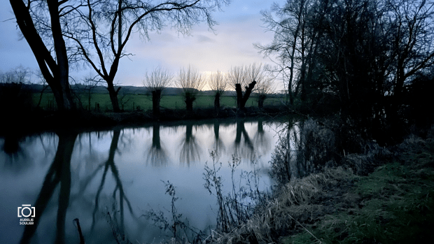
My journey started with an early drive to Didcot before dawn on Sunday morning. There, I parked by Sophie’s house (who joined me on the last leg) by which time it was just getting light. I walked to the station to catch the bus. The 33 Connector runs from Didcot Parkway to Wallingford. But Google maps got me to walk a weird way in the opposite direction from the station. I realised as the bus was due to arrive…and there it was heading towards the station as I frantically ran all the way there. Luckily it was running late and I got in, got a ticket and took my hat and gloves off, and caught my breath. By Station Road further in Didcot, the bus driver had an altercation with people, asking a van to move out the way and a lady in a Christmas hat came shouting at him at the window. He proceeded to get out the bus again and gave a phone call. Then we went back on our way. At that point I was a little worried of timings. I felt it was then likely I would finish these 14 miles in the dark, perhaps for the last hour. I did bring a headtorch and a reflective vest so it was a risk I’d prepared for. I hadn’t anticipated it would be because of the bus however! (but that never happened as I finished before sunset)
It was very cold all day.
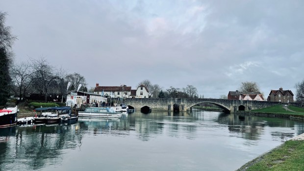
I started from Wallingford bridge and walked on the south bank of the Thames, past Wallingford Castle meadows, which is a lovely kind of nature reserve. From there, looking back at Wallingford allows you to see St. Peter’s church spire, which is quite a pretty sight.
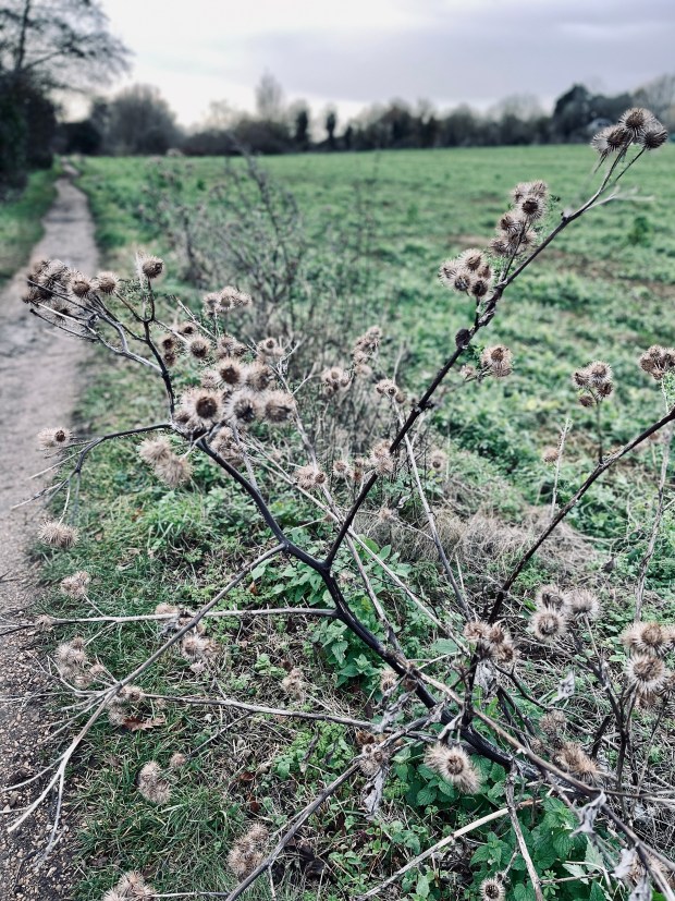
It was quite windy which made a cold day feel sharply cold. I was wearing woolly gloves, a hat and my winter hiking shoes. I am glad I swapped from my trail running shoes to the warmth and comfort of these winter shoes because the start of the walk from Wallingford was muddy and wet on the ground. Even though, a bit further, as I approached Benson, there were some dry patches, the mud then proved a bit of a regular theme through the day.
It was so nice to be back there by the Thames, especially when I started to hear the sounds of the water by Benson’s lock, now becoming a familiar and reassuring feeling: it’s a nice place to come back to every fortnight.
At Benson lock, there is a little bridge to go over to the lock, and then another bridge crossing to the middle island with a beautiful little lock house from the early 20th century. From then I was on the North bank of the Thames.
By Benson Marina, in the waterfront park where there’s a small swimming pool which is the moment empty because of winter weather and probably COVID. Through the trees, there, on the other side of the road, we can see just about the Benson church. Then I went past a Waterfront Café which looked lovely but was closed so I’ll come back there another day.
The Thames past is diverted away from the riverside at Shillingford bridge.
The walk along the road in Shillingford was horrible. It’s not very nice. I was glad to get back to the Thames. There I had my sandwich in a bus stop, feeling sorry for myself having failed to bring my phone charger pack (which I usually always take with me). It was cold and pretty grim!
After Shillingford, I noticed my phone’s battery power (which I also use as my camera) had halved since it was fully charged at 08:00. The brightness on my phone was too high. As a result I decided to turn off a lot of function on the phone and switch it to airplane mode to save battery.
Sadly, I went past Dorchester-on-Thames and could just about see its church but I couldn’t stop and visit without making myself late and risking walking in the dark. It’s meant to be a lovely Roman town and I hope to return and visit some day soon.
I went past a few fields with sheep. I was hoping for less windy and cold as I crossed back over to the South bank just after Dorcherster-on-Thames but I just walked totally straight in headwind for much of the rest of the day.
Day’s Lock was nice and I saw a handful of people around there, a contrast to the relatively lonely morning of walking so far. I thought I was going to cross on the first bridge (very shiny!) but I ended up crossing over the weir. Crossing the Thames on a weir doesn’t fail to be entertaining and exciting. There is something special, maybe some kind of adrenaline rush, to find yourself over a thin bridge, looking down at the strong water flow under your feet and hearing the rush of the river. I don’t get tired of it.
The cold was making my face very cold and it started to rain; the rain was freezing so I wore my fabric face mask which I keep in my pocket to get in shops and cafés… it was helpful and I then decided I should get a buff for my next walk!
From there, I walked towards Clifton Hampden. I kept seeing the two remaining cooling towers from Didcot (I got to see the big towers being taken down a few years back): it felt like I was on the perimeter of a circle around Didcot, keeping them mostly on my left. I saw much wildlife on the way today. A lot of red kites, a few flocks of geese, and about 5 herons but they were very elusive so difficult to photograph with my frozen hands.
I stopped at The Barley Mow for lunch. It was very nice and great to have a warm meal after that earlier cold sandwich in a bus stop shelter. I picked up a little bit of local reference to Jerome K. Jerome there with the mention of that pub in Three Men in a Boat: (To Say Nothing of the Dog).
There I switched back to the North bank of the Thames. The path got muddier, the wind got colder and the rain got more regular as I left Clifton Hampden.
I saw some cow in a field on the way and they were very curious about me. I wonder if they thought I’d feed them?
I went under a railway bridge by Appleford.
From then on the landscape was not very different from the rest of the walk, and I kept my head down a lot with the cold weather. The rain stopped on and off but it was mostly dry after Culham bridge.
Culham Lock
I took a nice glimpse of the sunset a little after Culham lock.
flock of geese
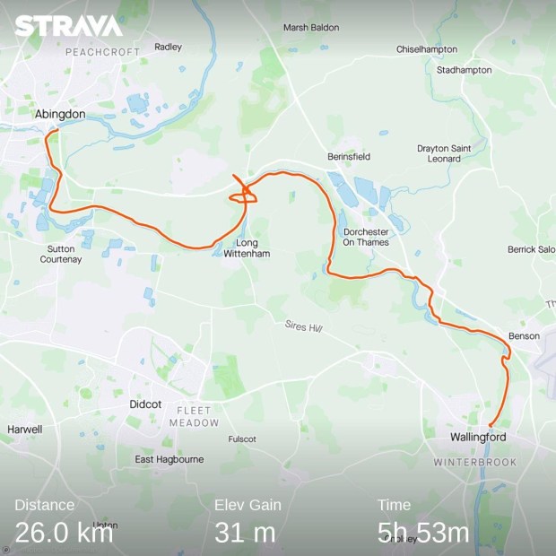
Finally, the last stretch to Abingdon was pleasant (if a little muddy) and reminded me of the stretch getting into Chertsey last month.
I arrived on Abingdon bridge after 6h30’s walk. It was time for me to grab a hot chocolate and hop on a bus back to Didcot.
Now to plan for the next 5 days which are likely to be in very cold weather, just before Christmas.
Today I had the lovely company of Sophie and of Libby the dog for our 11 miles walk to Wallingford. The sun was shiny on this cold Sunday morning bringing so much shine to the lovely November colours in the trees.
We started the walk on Whitchurch bridge, leaving Pangbourne behind us.
At Whitchurch, we didn’t follow the Thames as the Thames Path takes it’s longer diversion off the Thames side. Instead we were taken uphill in beautiful woods with lovely colours around us.
It was lovely to walk with company and we kept a very good pace. The sunny morning made it easier too. Opposite the Grotto (in the other bank) and as we started to encounter more dog walkers, we realised that we were already approaching Goring.
In Goring took a right by the bridge and stopped for coffee and food at the Pierreponts Café. Not only it was a dog-friendly café but the food was yummy and filling and the décor lovely. We crossed the bridge and took a right in Streatley following the Thames Path signs. It reminded me of the few times I took a train to Goring and, walking that way, headed straight up the hill (instead to taking today’s right turn) towards the Ridgeway and walked home via the Ridgeway.
We had a little peek inside St Mary’s church in Streatley. A blue plaque showed Lewis Carroll preached there.
The path took us back to the riverside where we walked through the autumn leaves.
Shortly after the lock and weird, we saw a blue kingfisher (Sophie spotted it) on the other bank in a tree, but I wasn’t quick enough to get my phone out.
As we went past a nature reserve, we saw a rainbow which was a surprise on this sunny morning, then there was a bit of cold drizzle which stopped pretty soon after.
We heard the loud bells from South Stoke church and Sophie spotted a heron perched on tree, catching the sun . It’s not clear in the photo but that’s the best I could get.
Through Moulsford the Thames Path took us away from the river again along the A329 for a little bit. When we rejoined the riverside, we went under a railway bridge and then through Cholsey nature reserve. There were a lot of rowers going past. We sat on a deck for a little break and watched rowing boats going past.
We went under the A4130 and the weather had started the warm up but then turned windy and cold again.
We reached Wallingford and stopped in St Peter’s church for a minute then walked to the Bridge: the end of our walk for today.
We walked 11.85miles (19.07km) in under 4h45, from Pangbourne to Wallingford. We then walked around Wallingford a bit and found a dog-friendly pub (the Cross Keys), played dominos with a cup of tea while we waited for our roast dinners, and then went onto our bus stop for our onward journey. I’m planning to get back to Wallingford in a fortnight, weather permitting, to continue on the Thames Path.